Residential and Experienced Urban Segregation
The spatial segregation of different socioeconomic groups has been rising in many cities across the globe, inhibiting equal access to local public goods and undermining social mobility. This PhD project investigates how urban planning policies both mitigate and produce socioeconomic segregation in cities.
- The first part of this PhD project investigates how changes in land use plans affect rent prices and the location choice of different socioeconomic groups. Specifically, it studies the effects of changes in land use plans that densify the built environment for the case of Zurich, using detailed geo-coded panel data on land use plans, rents, and households.
- A second project uses cell phone data for Colombia to study experienced segregation, i.e. segregation in everyday life places such as coffee shops, parks, or gyms, and how access to public transit increases the probability of meeting individuals from other socioeconomic groups.
Introduction
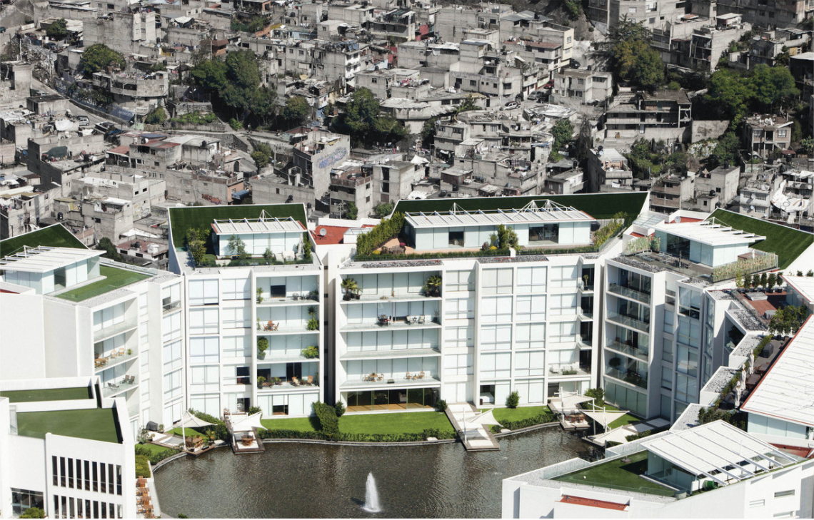
Economic segregation is “the geographic manifestation of income inequality”. Consequently, the recent growth in income inequality in many economies reflects itself in growing socioeconomic segregation in cities. For instance, neighborhood segregation in NYC and Philadelphia grew by 40% in the 1970-2010 period (Mijs & Roe 2021). Segregation also grew in other US and European cities and in Latin America. This increasing socioeconomic segregation has a host of alarming negative consequences, such as creating unequal access to local public goods (e.g. good schools and parks). This in turn undermines social mobility and societal cohesion. Thus, it is important to know what governments can do to stop the trend of increasing socioeconomic segregation in large cities.
Against this backdrop, this PhD project studies how specific urban planning policies affect the degree of socioeconomic segregation in cities. This is interesting from a policymaking perspective since urban planning (e.g. land use regulation or public transit) is central to the location choice of rich and poor households within cities. For local governments, urban planning is often the key instrument to address socioeconomic segregation, as other instruments are the competencies of state or federal governments. The PhD project is also interesting from an academic perspective, as new developments in urban planning, such as the paradigm of urban densification, raise new questions about segregation in urban areas. Furthermore, new fine-grained big data from web-scraping or cell phones’ GPS location enable this project to study the effects of urban planning policies on segregation and residential location choice in more detail.
The Project
This PhD project seeks to understand the effect of changes in land use regulation and public transit provision on residential and experienced socioeconomic segregation in Zurich in Switzerland and Bogotá in Colombia. The project uses geo-spatial observational data and state-of-the-art methods of causal inference. Specifically, this PhD project consists of two blocks:
Densification & Residential Segregation in Zurich
- Research question: What is the effect of changes in land use regulation that allow for more densification on rent prices and residential income segregation in the Canton of Zurich? Do densification policies lead to the replacement of old low-rent housing stock with newer, high-end housing and thus drive up rents leading to the displacement of poorer households?
- Methods: The project analyses data on land use plans, construction activity, rents, and administrative data on household income, education, and movement decisions. The investigators use staggered difference-in-difference regression to causally identify the impact of changes in land use regulation on rents and socioeconomic household sorting. Some project parts also zoom in on certain train stations using case studies.
- Preliminary results: Current results show that on average changes in land use do not lead to faster rent increases in treated areas compared to other non-treated areas. Yet, this strongly depends on initial neighborhood characteristics: if a neighborhood is initially relatively poor, but centrally located and well connected, then more construction happens and rents increase. This shows that the effect of the new planning paradigm of densifying cities can vary strongly and that poorer neighborhoods need additional measures to avoid local rent increases.
Experienced Segregation & Public Transit in Bogotá
- Research question: The project studies experienced segregation, defined as the segregation by income and gender in public and semi-public places, such as restaurants, parks, or bus stops (see e.g. Moro, Calacci, Dong & Pentland 2021 for more information). Which individuals live the most segregated lives? Does good access to public transit decrease experienced segregation for low and middle-income individuals?
- Methods: The project uses GPS data from cell phones and Google points of interest data to investigate how likely an individual is to co-locate with individuals from different socioeconomic groups or a different gender in public and semi-public spaces. After identifying broad general patterns of experienced segregation of Bogotá’s inhabitants, the project studies whether comparable individuals living in areas with good access to public transit live less segregated everyday lives.
Publications
Büchler, S and Lutz, EC (2021). The Local Effects of Relaxing Land Use Regulation on Housing Supply and Rents (November 10, 2021). MIT Center for Real Estate Research Paper No. 21/18, Available at SSRN: external page https://ssrn.com/abstract=3960822
Büchler, S and Lutz, EC (2024). Making housing affordable? The local effects of relaxing land-use regulation. Journal of Urban Economics, Volume 143. external page https://doi.org/10.1016/j.jue.2024.103689
Lutz, EC, Kauer F, Kaufmann, D. (2023). Mehr Wohnraum für Alle? Zonenplanänderungen, Bauaktivität, und Mietpreise im Kanton Zürich von 1996-2020. ETH Research Collection. external page https://doi.org/10.3929/ethz-b-000603242
Lutz, EC, Wicki M, and Kaufmann, D. (2023). Creating Inequality in Access to Public Transit? Densification, Gentrification, and Displacement. ETH Research Collection. external page https://doi.org/10.3929/ethz-b-000618124
Lutz, E., Wicki, M., & Kaufmann, D. (2024). Creating inequality in access to public transit? Densification, gentrification, and displacement. Environment and Planning B: Urban Analytics and City Science, 0(0). external page https://doi.org/10.1177/23998083241242883
Partners

MIT Center for Real Estate
Simon Büchler (MIT Center for Real Estate)
Neave O’Clery (University College London, CASA)
Samuel Heroy (University College London, CASA)
Team Members
Doctoral Candidate
Raumentwicklung und Stadtpolitik
Stefano-Franscini-Platz 5
8093
Zürich
Switzerland

Doctoral Candidate
Raumentwicklung und Stadtpolitik
Stefano-Franscini-Platz 5
8093
Zürich
Switzerland

Researcher
Inst. f. Raum- u. Landschaftsentw.
Stefano-Franscini-Platz 5
8093
Zürich
Switzerland
Supervisor
Deputy head of Inst Spatial and Landscape Development / Head of Network City and Landscape ARCH and BAUG
Raumentwicklung und Stadtpolitik
Stefano-Franscini-Platz 5
8093
Zürich
Switzerland